What is the purpose of understanding the land plot diagram correctly?
Before conducting land and house sales transactions, the most important issue is that the buyer needs to know how to view the land plot diagram and documents certifying land use rights. By properly understanding the plot map, you can know information such as:
Helps buyers to know the location of the land plot to conduct the sale transaction
Know clearly the shape of the land plot before deciding to buy.
Know the length of the sides of the land plot by the length shown on the land plot diagram and clearly know the number of the top of the plot for land plots with many sides.
Know the number of plots adjacent to the plot of land and the direction of the plot according to the North - South direction.
Know the boundaries and landmarks of land use planning, avoid the risks of transferring land within the boundaries and landmarks of planning.
Helps buyers to know the boundaries and safety corridors of projects related to the land plot such as transportation systems, electricity, irrigation systems, etc.
II. THE IMPORTANT INFORMATION OF THE LAND PLOT DIAGRAM IN THE RED BOOK
Pursuant to the provisions in Appendix No. 02 attached to Circular 23/2014/TT-BTNMT guiding land plot diagrams, land plot diagrams are shown on the basis of cadastral maps or cadastral measurement extracts or financial records. Other measurement data were used to issue the Certificate.
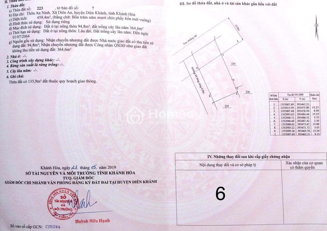
The content of the diagram includes: land plot shape; length of land plot edges; plot number or name of adjacent building; North - South directions; boundary lines, detailed land use planning boundary markers, boundary markers, corridor markers to protect the safety of works related to the land plot. As follows:
Land plot number: is the land plot number on the local cadastral map according to regulations of the Ministry of Natural Resources and Environment.
Map sheet number: is the ordinal number of the cadastral map containing the land plot issued with the Certificate within each commune/ward level administrative unit.
Land plot address: is the name of a residential area such as hamlet, commune, village, ward, district, house number, street number, etc. belonging to the level of government managing that land.
Land area: is data showing the usable area of land in units of square meters (m2) and rounded to 1 decimal place.
Land plot diagram: shown by closed solid lines, is an illustration of land enlarged or reduced according to the ratio printed on the land use rights certificate to help land users easily visualize.
Land use planning boundaries are shown by continuous dotted lines and arrows indicating the direction of the planning scope; The boundaries of the public works protection corridor are shown by 3 dots interspersed with dashed lines and arrows indicating the direction of the safety corridor.
III. INSTRUCTIONS ON HOW TO READ REPAIR DIAGRAMS ACCURATELY
The land plot diagram is one of the most confusing and difficult to read contents of the land use rights certificate. To view the plot map accurately, you can follow the instructions as follows:
1. Contents of the land plot plan
The shape of the land plot horizontally and vertically.
Land plot numbers or names of adjacent structures such as roads and bridges pointed in the North - South direction.
Boundaries and landmarks according to land use planning, construction protection corridors on the land plot, and surrounding air circulation area are shown in dashed lines with annotations.
If excess land is separated from a common plot of land with different usage periods, it will also be shown with broken lines and clear notes.
2. Form of land use
To use land reasonably and legally, you need to see the assets attached to the land area under your ownership on the land plot map. Accurately determining the assets on the land area you own helps you know what form of use the land is in order to use the land for the right purpose, without violating current laws.
Land use rights and duration are divided into the following cases:
Private use: plots of land owned by an individual, a household, an organization, a residential community or a religious institution.
Common use: plots of land owned by two or more people.
Common use and private use with area data: this case is often recorded in land plots combined with residential land, agricultural land, pond and lake land.
Based on the above land use forms, land is divided into different types and land groups including residential land, agricultural land, and non-agricultural land. The land use period will also be specified on the land plot documents. Specifically, the land use period is as follows:
Long-term residential land.
Land has a specific use period from day to day.
The State allocates land to organizations and individuals with collection of land use fees.
The State allocates land to organizations and individuals without collecting land use fees.
The State leases land to organizations and individuals with annual payments.
The State leases land to organizations and individuals with a one-time payment.
Recognition of land use rights as land allocation without collecting land use fees.
Recognition of land use rights as land allocation with collection of land use fees.
Land lease with one-time payment from an enterprise investing in industrial park infrastructure.
Land lease with annual payments from enterprises investing in industrial park infrastructure.
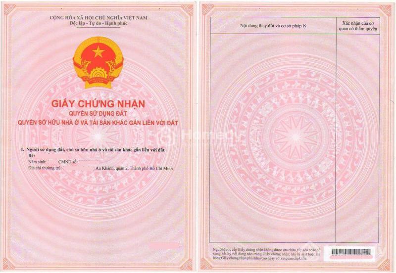
People often call these types of paper based on color. That is the pink book or red book that we often call it.
The pink book is a certificate of land use rights, ownership of housing and other assets attached to land issued by the Ministry of Natural Resources and Environment based on Decree 88/2009/ND-CP dated October 21. /2009. This new pink book form is the current common form. Before Decree 88/2009 took effect, specifically December 10, 2009, there were 3 types of books: red books, old pink books, and white books.
Red book: is a land use right certificate issued for rural land, agricultural land, forestry land, aquaculture land, and salt production land (non-urban areas). This form is issued by the Ministry of Natural Resources and Environment based on Decree 64-CP; Circular 346/1998/TT-TCĐC.
Old pink book: is a certificate of housing ownership and land use rights issued for land in urban areas. This old pink book form was issued by the Ministry of Construction based on Decree 60-CP dated July 5, 1994.
White book: There is no document that specifically regulates what a white book is, but in reality many localities consider white books to be documents such as land titles, house purchase and sale documents, etc.
Below the cover page is the draft number of the notebook sample. The state prints the form and sends it to the locality. If the locality issues a book to someone, the locality will have its own number to track. That is called the number in the certificate issuance book, usually recorded at the bottom of page 2.
3. How to read the plot diagram according to the current red book
Page 1: Information of the person whose name is on the book
Provide information about land granted to individuals, households or organizations. See Article 5 of Circular 23/2014/TT-BTNMT on certificates of land use rights, ownership of houses and other assets attached to land issued by the Minister of Natural Resources and Environment.
Regarding the issuance of books to households, from December 5, 2017, following the provisions of Circular 53/2017/TT-BTNMT, there will no longer be names of household members on the books, only Write the name of the householder only.
Page 2: Land and housing information
Land plot information
Address of the land plot.
Recognized area. Unrecognized area (usually encroached land) or vacant land area.
The dimensions of the edges are based on the current status drawing in the book written directly on the edges. Or based on the distance between points.
The purpose of use is residential land, growing perennial crops land, land for growing annual crops, agricultural land, etc. If you want to change the purpose of use, you must go through conversion procedures at the competent authority.
Determine the common area or common path.
Is the land use term long term or up to how many years? If there is a term, at the end of the term the landowner must go through procedures to extend the use. Once the time limit recorded on the book expires, the landowner cannot continue to carry out transfer transactions on that land.
Determine the direction of the land plot: the arrow points to the North, the right is the East, the left is the West.
Determine assets attached to land: record at the location of other construction works.
Determine the number of land plots and the number of map sheets.
Origin of land use: for residential land, there is the phrase: “The state recognizes land use rights with land use fees collected”. For land planted with annual crops, it is “the recognition of land use rights is recorded as land allocation without collection of land use fees”.
Housing information:
Understand the symbolic records of housing on the books:
Home address.
Construction area is the area of the house built on the plot of land.
Floor area is the area of the construction site. (If built enough, it is calculated by construction area x number of floors).
Structure: concrete, brick walls, wood, corrugated iron roof,...
Number of floors
Level (class): level 2, level 3 or level 4.
House drawing: Often In Ho Chi Minh City, this section is updated with more details.
Important information on pages 2,3
Page 3, 4: Planning information
Planning information:
See planning information on the red book:
Planning information in the notes section, including whether there will be compensation if it is revoked.
The area covered by the planning based on the plot diagram.
Changing information.
See if the book has transfer rights restricted or not, information about rights restricted.
Certification agency: district, department of natural resources and environment or People's Committee, centrally governed city.
Hopefully the information on how to view a plot of land above is useful to you, helping you grasp important information to choose a real estate product that suits your needs. Please follow TSH for more information about real estate.
Để chọn cho mình một căn hộ như mong muốn không phải là chuyện dễ dàng. Khi thời điểm hiện nay đã có rất nhiều dự án căn hộ, chung cư mọc lên với đầy đủ những lợi thế và...